But people ignoring weather forecasts is not a new thing. Remember Noah and the flood?
Tuesday, November 25, 2014
Buffalo Lake Effect Forecasters Get It Right!
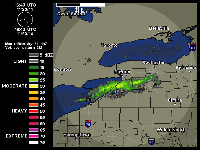
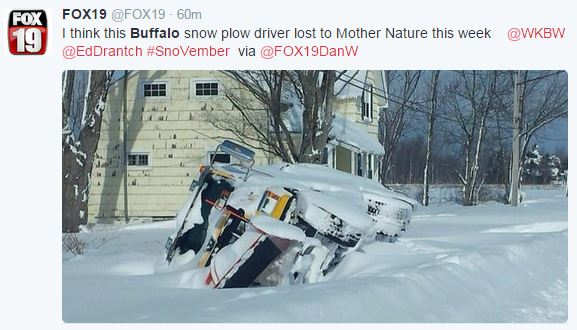
Despite the governor of New York's criticism of the National Weather Service and his incorrect statement when he said, "no one had any idea that there would be that much snow" please understand that the meteorologist forecasting the intense lake effect storm got the forecast right! See Article. Five days in advance the NWS reported the possibility of Lake Effect. Three days in advance they released an official warning forecasting several feet of snow. See article.
But people ignoring weather forecasts is not a new thing. Remember Noah and the flood?
But people ignoring weather forecasts is not a new thing. Remember Noah and the flood?
Friday, November 21, 2014
Rain Droplet Growth: Collision-Coalescence Efficiency
When rain drops grow by collision and coalescence not every drop of water it hits gets absorbed by the bigger droplet. We therefore need to include an efficiency term in our equation of droplet growth.
Below is a video by Reid Wiseman, an astronaut at the International Space Station, demonstrating the collection efficiency of a raindrop.
 |
Thursday, November 20, 2014
Welcome back to the prolonged inversions and poor air quality
Air quality along the Wasatch Front has been getting worse the last few days. Salt Lake City is the winter home of temperature inversions and bad air. And this is just be beginning of the season. Below are shown measurements of PM 2.5 (Particulate Matter smaller 2.5 micrometers in size).
The air is not super unhealthy yet, but the pollution concentration is increasing. You may have noticed the decreased visibility last time you tried looking at the mountains across the valley. This weekend a storm should blow all this gunk away before it gets much worse, but be prepared for more days like this and try to drive less during these inversion periods if you can.
 |
| November 19, 2014 @ 2:50 PM Photo: kbkb |
 |
| November 20, 2014 @3:30 PM Source: WBB webcam |
Above is another look at the smog today. The sun is beginning to set. The concentration of the smog actually looks worse due to the fact that we are looking in the direction of the sun. When particles scatter light, they always scatter with constructive interference in the forward direction, toward your eyes if you are looking toward the sun. This optical phenomenon makes the haze look brighter, making it seem there is more stuff in the air. But still, the air is dirty.
 |
| source: atmospheric radiation course notes |
More Snow for Buffalo
Wednesday, November 19, 2014
HRRR Forecast Skill
Curtis Alexander from NOAA/ESRL gave a webinar talk titled "Progress and plans for the operational HRRR model." The talk can be found here.
Below is just one slide from his presentation. It shows forecast skill of different methods of forecasting the weather. A persistence forecast, saying the weather will be the same later as it is now, has no skill beyond an hour. Extrapolation, or saying the weather trend will continue, does pretty good for an hour, but skill quickly decays. The HRRR model (dark green line) produce a better forecast than extrapolation after the first hour. After the first forecast hour the HRRR model is more accurate than persistence and extrapolation. As with all weather models, the forecast skill of the HRRR degrades over time, but still there is more skill in a HRRR forecast at six hours than a simple persistence or extrapolated forecast.
HRRR FAQs
HRRR Forum
Tuesday, November 18, 2014
40+ inches of snow: Buffalo Lake Effect
A strong lake effect snow storm has set up over the Great Lakes region today dumping over 40 inches of snow areas near Buffalo, New York. Lake effect snow storms are characterized by a stationary band of precipitation. In the radar loop below you can see the band of precipitation stays in the same spot. This is why they get so much snow!
Below is the visible satellite image
A time lapse video below shows is quite impressive.
For more pictures see Capital Weather Gang and Wasatch Weather Weenies blog posts.
Monday, November 17, 2014
It's Cold
Woo-Hoo! We almost got above freezing today!
 |
| source: NWS |
The Provo Airport was actually one of the more cold areas along the Wasatch Front. Many stations have reported high temperatures above freezing, but I didn't see any temperatures above 40 today. Below show 24 hour max temperatures.
 |
| source: mesowest.utah.edu |
 |
| source: mesowest.utah.edu |
Tomorrow (Tuesday) will be cold again...
 |
| source: preview.weather.gov/edd |
but we will warm up a little Wednesday, a little more on Thursday, and a little more on Friday (shown below)...
 |
| source: preview.weather.gov/edd |
Saturday, November 15, 2014
Alaska: Pavlof Volcano Eruption
Last week I told the scouts in my weather merit badge class that volcanoes have nothing to do with the weather. That isn't really true. When a volcano erupts, the weather becomes very important...
Volcanoes are a source of aerosols and gases that get spread around the atmosphere. They can cause cooler temperatures because these aerosols reflect a lot of solar radiation back to space. The ask isn't good for airplanes to fly through. Lightning is also common after volcano eruptions. Weather forecasts help predict were the ash will be transported.
MODIS satellite Image on November 15, 2014 captured a view of the ash cloud:
Below is a HYSPLIT model at the location of the volcano. It is an ensemble of trajectories based on atmospheric conditions that show where the ash will be transported to in six hours. Looks like the winds will likely shift from what is shown in the image above and the ash will be transported further north.
Volcanoes are a source of aerosols and gases that get spread around the atmosphere. They can cause cooler temperatures because these aerosols reflect a lot of solar radiation back to space. The ask isn't good for airplanes to fly through. Lightning is also common after volcano eruptions. Weather forecasts help predict were the ash will be transported.
MODIS satellite Image on November 15, 2014 captured a view of the ash cloud:
When we zoom in and look at the shadow this plume casts, you can get an idea of how tall this plume of smoke really is. The ash reaches about 35,000 feet!
 |
| source: NASA Worldview |
Below is a HYSPLIT model at the location of the volcano. It is an ensemble of trajectories based on atmospheric conditions that show where the ash will be transported to in six hours. Looks like the winds will likely shift from what is shown in the image above and the ash will be transported further north.
Light Snow
Getting some light snow in Spanish Fork this afternoon. It's perfect stuff for snowballs and snowmen!
Thursday, November 13, 2014
An Unusual Excitement on the Subject of Snow
It commenced with the skiers, but soon became general among all people along the Wasatch Front. The people listened to their favorite meteorologist for the latest weather forecast. Some forecasting, "a trace of snow here!" and others, "three inches there!" Some contending for snow in the valleys, others for only rain.
During this time of great excitement I too was interested in how much snow we would receive. During this great excitement I hoped for lots of snow, and I looked at the many weather models for guidance.
I first looked at the GFS, and felt that it could be a good guess. But other models, like the 12 km NAM, had much less snow in the valley, while the 4 km NAM put more snow in the valleys.
However, HRRR thins out the precipitation quite a bit, and sends most of the snow to the northern most part of the state...
The SREF, on the other hand, calls for high probability of snow and an inch or two of snow in the valley, with much higher chances in the mountains.
Still, it is difficult to predict how much snow we will get, and where that snow will fall. The 3-hour snow forecasts from a 21-model ensemble for Salt Lake spreads across such a great range, between .25 inches and 1.25 inches of snow...
What is to be done? Which of all these models is right; or, are they all wrong together? If any one of them be right, which is it??
Wednesday, November 12, 2014
We Just Landed on a Comet
 |
| Philae shortly after released from Rosetta, on it's way to the comet. Source: www.esa.int |
Rosetta and Philae traveled 4 billion miles in ten years to catch the comet. The comet and spacecraft are now only so far away that it takes 30 minutes before a radio signal from Philae reaches earth. (From a quick calculation using the speed of light, the comet is now only 300 million miles away. Someone check to see if that is right.) In comparison, it only takes 15 minutes before we receive a signal from the Mars rovers.
Rosetta arrived at the comet in August and has been orbiting the comet the last two months looking for a good location for Philae to land. The comet, known as 67P/Churyumon-Gerasimenko (named after those who discovered it), was discovered in 1969. (If you are interested in learning more about discovering comets and planets, I would suggest reading How I Killed Pluto and why it had it coming, by Mike Brown.)
One of the biggest surprises from the Rosetta mission so far is how irregularly shaped the comet really is...
Just how big is this comet? About the size of a Federation Space Dock...
Philae isn't quite the size of a pixel in this image.
Highlights from the European Space Agency:
How it worked:
A Cold Wind
This morning was cold and a little windy. Shown are some MesoWest observations of the wind speed and gusts this morning around 7:30. (Click image for bigger picture).


A STRONG 1049MB SURFACE HIGH IS SEEN IN SURFACE ANALYSIS OVER CENTRAL MONTANA AND NORTHEAST WYOMING THIS MORNING...ASSOCIATED WITH AN ARCTIC AIRMASS THAT HAD ENTERED THE GREAT PLAINS. THIS HIGH IS PRODUCING A STRONG NORTH TO
NORTHEASTERLY PRESSURE GRADIENT INTO UTAH...WHICH HAS ALLOWED SOME
OF THE COLD AIR TO SEEP INTO THE AREA. COLDEST SPOTS IN THE FORECAST
AREA AT THIS TIME ARE IN SOUTHWEST WYOMING...THE BEAR RIVER
VALLEY...AND FAR NORTHERN UTAH WHERE SINGLE DIGIT TO NEAR ZERO
TEMPERATURE READINGS ARE BEING REPORTED.
WITH THE GRADIENT REACHING AS FAR AS SOUTHERN UTAH...COOLER MAX TEMPERATURES ARE EXPECTED EVERYWHERE TODAY...WITH 24HR CHANGE OF
AROUND 5 DEGREES ACROSS FAR SOUTHERN UTAH TO 15 DEGREES ACROSS
NORTHEASTERN ZONES. NORTHERN UTAH IS NOT LIKELY TO REACH 40 DEGREES
AND WILL STRUGGLE TO EVEN REACH THE MID 30S IN MANY AREAS.
THE CROSS-BARRIER ORIENTATION OF THE SURFACE GRADIENT THROUGH THE
NORTHERN MOUNTAINS HAS PRODUCED LOCALIZED GUSTY CANYON WINDS ALONG
THE WASATCH FRONT AND CACHE VALLEY. OVERNIGHT GUSTS HAVE BEEN IN THE
30-40MPH RANGE AND ARE NOT EXPECTED TO STRENGTHEN MORE THAN ANOTHER
5 OR SO MPH FOR THIS MORNING DUE TO THE SHALLOW NATURE OF THE
EASTERLIES. THESE WINDS WILL WEAKEN A BIT THIS AFTERNOON...BUT WILL
REMAIN ELEVATED THROUGH THE NIGHT BEFORE THE GRADIENT FINALLY
RELAXES TOMORROW MORNING.
Subscribe to:
Comments (Atom)


