Showing posts with label mesowest. Show all posts

Monday, May 6, 2019

Impacts of high-frequency radar-derived wind observations on COAMPS® forecasts

I recently submitted a proposal for the National Research Council Research Associateship Program (http://sites.nationalacademies.org/pga/rap/). The proposal is to work at the Naval Research Laboratory in Monterey, California as a post-doctorate researcher on a data assimilation project.

The full application can be found here: https://1drv.ms/b/s!AtJL0JL_rT9judo3fc85wl5SkgOIiQ

Abstract

Shore-based high-frequency (HF) radars are routinely used to observe ocean currents and surface wave characteristics remotely. Because surface waves are closely related to near-surface winds, many investigators have explored methods in deriving winds from HF radars, with limited success until now. Most recently, a technique has been developed that uses HF radar Doppler spectra data with the adjoints of a HF radar model and a wave prediction model to derive winds. This technique has been applied to HF radar data collected along the Santa Barbara, California coast during October 2017. These remotely sensed near-surface wind observations are likely to be valuable in initializing mesoscale analyses and forecasts in the littoral zone, as satellite-derived surface winds are generally not available near the coast. Since ocean wave models are dependent on atmospheric winds, better forecasts of near-surface winds impact almost all Naval operations near shore—especially transits in and out of ports. This work proposes to investigate the impact HF radar-derived winds have on the quality of Coupled Ocean/Atmosphere Mesoscale Prediction System® (COAMPS) analyses and forecasts using the new COAMPS-4D Variational data assimilation system. An observing system experiment is proposed to evaluate impacts from real HF radar observations on COAMPS followed by a historical observing system simulation experiment to determine potential impacts from simulated wind retrievals.

FIG. 1 Southern California coast surface wind observation network available 14 October 2017. Locations of the HF radar network are denoted by green triangles and automated weather stations and buoys are denoted by red dots.
FIG. 2 Observed near-surface vector wind at 17:25 UTC 14 October 2017 from MetOp-B ASCAT scatterometer (black) and automatic weather stations and buoys (red). Half and full barbs denote 2.5 and 5 m s-1, respectively.


Tuesday, April 24, 2018

Changing Seasons

Time-lapse video is taken on top of the William Browning Building at the University of Utah. By stitching images together we can see the sun positon change with the changing seasons. The dates below are for the year 2018 and the time is the local time.


Tuesday, March 13, 2018

5 year Anniversary

What is my favorite kind of weather? Warm, sunny days😁

It has been over three months since we have seen temperatures in the upper 60s and 70s. I love going to work with a jacket instead of three layers of coats.

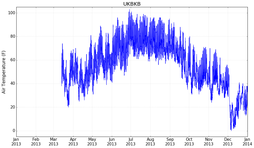
Today is the 5 year anniversary of my weather station on the Spanish Fork Bench, UKBKB (also known as EW2355). Here is a look at temperature in Spanish Fork between March 13, 2013 and March 13, 2018.


Wednesday, January 11, 2017

MesoWest: Celebrating 20 years of observations


This year, MesoWest celebrates 20 years of collecting, archive, and disseminating environmental data.

https://mesowest.org/20/

Thursday, December 15, 2016

Warm and cold night

Temperatures got warmer throughout the night in Spanish Fork

Now, moving north to the Point of the Mountain...

And finally the Airport. They were stuck in a cold pool all night, then southerly winds mixed out the cold air and temperatures rose quickly to over 54 C


Inversion this morning quite impressive from the morning rawinsonde:

 Check out the time series of Sodar data near the airport as the cold pool mixed out:


Thursday, December 8, 2016

Peter Sinks, Utah: One of the coldest places

The Peter Sinks in Northern Utah (near Bear Lake) is one of the coldest places in the lower 48 states.
Some info here: https://climate.usurf.usu.edu/PeterSinks/
and here: https://en.wikipedia.org/wiki/Peter_Sinks
From MesoWest: the PSINK and PSRIM sites at midnight on December 8, 2016

The temperature gradient between the rim and the valley, a 270 foot vertical difference, can be quite large. Over the last two days temperatures have plunged below -40 C.


Max, min, and mean temperatures for the two stations are shown below (need to apply some quality control on the data from the MesoWest API seeing that there is a max temperature in September of over a 105 F, which seems odd) Still, it is often quite cold in the Peter Sinks.

Thursday, October 6, 2016

Thursday, September 29, 2016

BFlat: New Weather Station at Bonneville Raceway


The MesoWest research group at the University of Utah set up a new weather station at the Bonneville Salt Flats speedway. The data from this weather station will be used to help study how the salt flats change over time.

The data can be viewed here: http://mesowest.utah.edu/cgi-bin/droman/meso_base_dyn.cgi?stn=BFLAT

The Bonneville Speedway is famous for the land speed records that are recorded there. Racing season is in the summer, when the salt flats are dry.

Today, the salt flats were wet. We had a lot of rain last Thursday. All that rain flowed downhill and pooled on the raceway.

The water at the end of the paved road was about a foot deep. The site for the weather station was three miles off the road. We didn't want to take out truck out there. Lucky, the BLM had an all terrain vehicle to ferry us and our equipment to the station site.

There were a bunch of tourists out to see the salt flats, and then wondering what the heck we were doing out in the water.

The three mile drive in the salt water took about 20 minutes to get to the site. Where the station was located there was less than a half inch of water. But the water was like a mirror. I got a sunburn, and some good pictures of the mountains and sky reflecting in the water.


On the drive back, I was sitting on the outside of the UTV, in the splash zone. After my pants dried, the right leg was white with salt. My face was also speckled. My lips sure were salty.

The salt got everywhere. The UTV was covered and someone managed to get us back to our truck without dying on us. It did have a lot of trouble. The salt water would spray up in the air intake and deposit there. It would also hit the exhaust system and the water would vaporize, leaving the salt behind caking the pipes. On the way back the tail pipe was almost completely closed off by salt. I wonder how much CO I breathed that day


Friday, September 25, 2015

Adventure on Fremont "Island"


The newest addition to the University of Utah's Mesonet is a weather station on Fremont Island. Fremont Island is located in the Great Salt Lake between Antelope Island and Promontory Point. It is named after John C. Fremont who was a military officer and explorer of the western United States. He visited Fremont Island and surveyed the Wasatch Mountain Range a few years before the Mormon pioneers reached the Salt Lake Valley.

We drove out to the island yesterday morning to set up the weather station. Yes, you read that right, we drove to the island. The cartoon map image above is a little deceiving. The Great Salt Lake Level is actually really low and there is now a land bridge that makes driving to the island possible. Note: The island is privately owned. We had permission from the owner to set up the weather station and he escorted us to the island. You can see from satellite images the land bridge that exists between the Antelope Island causeway and Fremont Island. When the lake level is high it is best to take a boat.

The image on the left shows when the lake is high. The right image was taken on 10 September 2015, just over a week prior to our excursion. The drive on the lake bed is really flat and sandy, as you can see below. That hill in the distance if Fremont Island.
Castle Rock is the highest point of the Island. We didn't hike there, but there is a famous cross carved in the rocks by Kit Carson who explored the west with John Fremont.

Kit Carson's cross (photo from the internet)
The images above makes it look like the island is barren, but the island really has diverse a diverse blend of vegetation and geological formations. Our wet summer has kept the plants green. The sagebrush especially gives lots of color to the island.

The island owner pointed out some cool rocks. They are little cubes of iron. I'm no geologist, so I can't say anything more about them.

After some wild four-wheeling on the island, we reached Miller's Point or Miller's Hill which turned out to be a perfect place for a weather station.
Our escort had an ATV.
Climbing Miller's Hill
Millers Point Survey Marker
Installing weather station on Miller's Hill.


Had to get my "Station Selfie" before we left. No idea when or if I'll ever be back here.

Weather data from this station (and thousands of other stations) can be accessed via MesoWest. 

Here is the past 24 hour temperature:

Past 24 hour winds:

More information about the island at Deseret News and this blog.