
Showing posts with label snow. Show all posts
Showing posts with label snow. Show all posts
Wednesday, January 18, 2017
Snow cover
We finally had a sunny day in Utah (though it is quite smoggy). Now we can see the extent of the snow cover in Utah.

Tuesday, January 3, 2017
Lots of snow
Six new inches of snow overnight in Spanish Fork. We shoveled last night, but we've got more to shovel today.


Wednesday, November 16, 2016
Storm's a comin'
The first half of this November has been comically warm. The temperatures at Salt Lake get warmer and warmer.


But our first winter storm is at our doorstep. Temperatures will begin to drop this evening and we'll see some snow in the mountains and the valley floor. Below shows the NAM forecast for 5:00 PM this evening. Going to work tomorrow will be considerably colder than it was this morning. The thermometer in my car said is was 57 F on my way to the train. Tomorrow morning will be closer to freezing.

Monday, September 26, 2016
Fall Mountain Snow
Outside my apartment is Mount Timpanogos. It has snow on it.

In fact, there is a lot of snow in the mountains across northern Utah. This is the Terra satellite image from September 25, 2016


In fact, there is a lot of snow in the mountains across northern Utah. This is the Terra satellite image from September 25, 2016

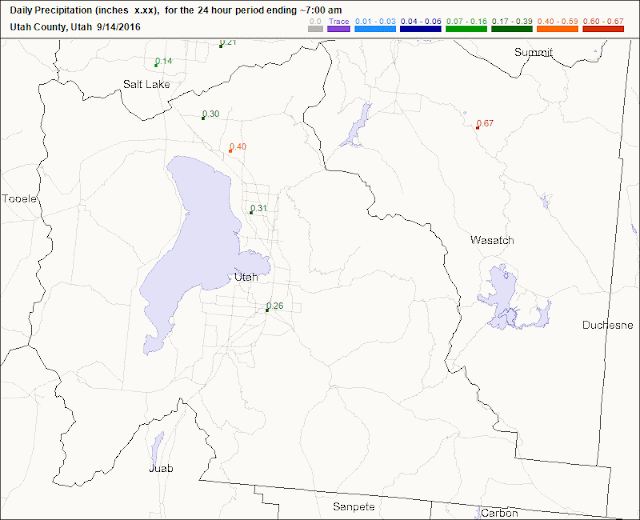
Wednesday, September 14, 2016
First sighting of snow!
Last nights rain and thunderstorm was quite impressive in Utah county. The lightning lit up the sky with long and loud bolts of lightning. I got off the train at 7:30 and drove to my new apartment in Orem in this downpour...
 The roads were splashed with so much water I couldn't see the lines painted on the road. Makes it hard to drive when you are staring at the sky watching the lightning!
My new roommate and I needed to pick up a few things at Walmart, so headed back out. After pulling out of the Taco Bell drive through it started raining again. By the time we got to Walmart it was another downpour.


It rained again around mid-night. This was quite the storm, and much needed for our drought parched valley. CoCoRaHS shows Orem-Provo had 0.31 inches in at least one spot.
This morning, I looked out the window and what did I see? Snow on Mount Timpanogos above 10,000 feet!


My new roommate and I needed to pick up a few things at Walmart, so headed back out. After pulling out of the Taco Bell drive through it started raining again. By the time we got to Walmart it was another downpour.

Jake was nice enough to drop me off at the door. When he got inside the store he looked like he had just got out of the shower with water dripping off his head and covering his glasses, making them useless. Ironically, one of the things we needed was a shower curtain.

It rained again around mid-night. This was quite the storm, and much needed for our drought parched valley. CoCoRaHS shows Orem-Provo had 0.31 inches in at least one spot.

This morning, I looked out the window and what did I see? Snow on Mount Timpanogos above 10,000 feet!

Thursday, February 18, 2016
Cold Front
On days like today the atmospheric sciences department cancels classes and graduate students abandon work. Students lined up against the window of the 8th floor conference room in the William Browning Building today as a massive cold front, the strongest one in years, approached. The cold front hit the University of Utah at 11:35. Temperatures dropped 20 degrees in fifteen minutes.


Notice the crane turned to the north. This is before the frontal passage with winds still strong from the south.

The crane turned south after the frontal passage.


Sunday, January 24, 2016
Snow in the east

Credit: NASA WorldView
Thursday, January 21, 2016
This is incredible!
 |
| Total new snow between now (Thursday morning) and Saturday Evening. This is a big storm. Source: EDD |
Read the Washington DC snow forecast:
https://www.washingtonpost.com/news/capital-weather-gang/wp/2016/01/21/blizzard-warning-high-winds-around-two-feet-of-snow-forecast-for-d-c-area/
Wow! Look at this noreaster...
 |
| NAM Forecast |
Tuesday, December 15, 2015
Winter Wonderland

This was the biggest snow storm in Utah in two years. Makes you wonder how many new Utah residents had their first experience driving in snow yesterday morning. I'm sure it was a shock to some. My commute was an hour longer than usual. The train and bus had no problem in the snow, but all the little two wheel drive cars we followed up the hill to campus sure struggled.
In Spanish Fork we had around eight inches of snow. My siblings had the sledding hill in the back yard built by the time I got home.

The commute this morning was much better and the side walks were mostly shoveled.


The Mountain Meteorology Lab at the University of Utah this morning is showing over 10 inches of snow (ignore the noise in the data, it's bad)

The largest snow totals were seen along the benches and areas further north. Utah county didn't get hit as hard Salt Lake county. The mountain snow totals are a little less impressive than one might expect. The winner of this storm was the Bountiful Bench which has 28 inches last reported.


Friday, December 4, 2015
New NWS Snow Forecasts
Here is a new product from the National Weather Service showing snow forecast probabilities for the next week.
http://www.wpc.ncep.noaa.gov/pwpf/wwd_accum_probs.php?fpd=24&ptype=snow&amt=1&day=1&ftype=probabilities

http://www.wpc.ncep.noaa.gov/pwpf/wwd_accum_probs.php?fpd=24&ptype=snow&amt=1&day=1&ftype=probabilities

Saturday, November 14, 2015
Snow Coming Sunday Night/Monday Morning
The storm is on its way. Sunday Night and Monday you'll see more snowflakes falling. It seems like the impact of winter storms are a distant memory to me, so prepare yourself for this season's first winter storm. It will likely have a big affect on your morning commute.
The NAM forecast below can be viewed at weather.utah.edu. This shows the approach of the pressure trough and the snow delivered to our mountains.

How much snow are we expecting?? We'll need to look at ensemble forecast to answer that question. Below shows the amount of snow expected in Salt Lake as forecasted by a dozen different models...
 It's usually a pretty good guess to take the mean of the models -- about 2-3 inches of Snow on Monday -- But that's not to say the models predicting over 5 inches are totally out to lunch (though, I'm less inclined to believe it). I'll stick with the mean on this one.
Another way to look at these ensemble forecasts is by looking at a probability of different amounts of snow. Study the different plots below... The one on the top right suggests all of Salt Lake and Utah County have greater than 90% chance of receiving more than an inch of snow in the next week. Most of that snow will occur on Monday. Mostly the mountains and benches have a high chance of receiving more than 6 inches. And only the highest peaks have a high chance of getting a foot of snow.

It'll be important to keep an eye on this storm, especially if you are commuting into work or school Monday morning. You'll want to give yourself some extra time, or maybe go in late and wait for the roads to be cleared.
The NAM forecast below can be viewed at weather.utah.edu. This shows the approach of the pressure trough and the snow delivered to our mountains.

How much snow are we expecting?? We'll need to look at ensemble forecast to answer that question. Below shows the amount of snow expected in Salt Lake as forecasted by a dozen different models...

Another way to look at these ensemble forecasts is by looking at a probability of different amounts of snow. Study the different plots below... The one on the top right suggests all of Salt Lake and Utah County have greater than 90% chance of receiving more than an inch of snow in the next week. Most of that snow will occur on Monday. Mostly the mountains and benches have a high chance of receiving more than 6 inches. And only the highest peaks have a high chance of getting a foot of snow.

It'll be important to keep an eye on this storm, especially if you are commuting into work or school Monday morning. You'll want to give yourself some extra time, or maybe go in late and wait for the roads to be cleared.
Thursday, November 5, 2015
It's Snowing

Yep, can't even see downtown.

Thursday, September 17, 2015

Friday, April 17, 2015
"Where is it now"
Remember that crazy storm that passed through Utah earlier this week? Today it's snowing in Colorado Wyoming and causing more problems. Here's a view of I-80: 33 semi trucks and 12 cars piled up on the roads.
 |
| photo from KSL |
Wednesday, April 15, 2015
And then there was Snow
It may be hard to believe, but this time yesterday's high temperature was 76 degrees at the airport. Right now it's 30. Since yesterday we've lived through extremely gusty winds (over 90 mph gusts in Parley's Canyon), a dust storm, muddy rain, and snow. The only thing that would have made it worse is a wildfire. Oh, wait. That happened too. Lots of active weather, which made for an exciting day--flight delays, accidents, jammed freeways, downed trees, "hey Dad, where is the trampoline". A power outage in Murray caused the train I was on to be delayed because the track switcher thing wasn't working. Add those delays to the delays in the morning and I spend a grand total of seven on public transit. Perhaps my worst commute day ever.


In Provo this morning there wasn't any snow accumulation. At the Eyring Science Center there was 0.23 inches of rain. In Spanish Fork my home only got 0.12 inches.
This morning on campus I was happy to see 6.5 inches of snow! Sure has been a long time since I've seen the white stuff.
CoCoRaHS observations show quite a bit of snow across the valley. It looks like the forecast was more or less right for most of the valley.
My Grandpa was begging me for some snow. Looks like Logan got a good share of it too...
From the radar you can see that it's still snowing over much of the northern part of the state.
The camera display shows the snow too...
How long will the snow last? By the late afternoon.
Thursday through Sunday our temperatures will creep back up to more spring appropriate temperatures.
My mom sent me this picture. Looks like it's snowing in southern parts of Utah County now.
Saturday, November 15, 2014
Light Snow
Getting some light snow in Spanish Fork this afternoon. It's perfect stuff for snowballs and snowmen!


Wednesday, January 30, 2013
Too Much Snow!!!....?
The Wasatch Front has been POUNDED with snow this week!!! Well, that is if you are comparing things with last year. While last year was much dryer than normal, much of Utah's snow totals so far this year are still below average despite "so much" new snow. Mother Nature hasn't been too friendly this January giving us extremely cold temperatures associated with a polluted inversion and then dumping us with three days of snow. Here's a question for you, would you rather live in a cold, dirty inversion or drive in the snow? I would much rather have the snow. I can ski in snow. What ever you think, don't get too sick of the snow yet: we still need more.
My thermodynamics professor loves the snow, too. He spend most of his research studying the stuff that fall from the sky. At Alta Ski Resort he installed a camera to take pictures of snowflakes in free-fall. The following are a few pictures his camera has captured:
 |
The following link includes the most recent snowflake pictures. If it is snowing at Alta new pictures will load up automatically. Enjoy! http://www.alta.com/pages/snowflakeshowcase.php
 |
| (Mobile ozone and temperature sensor: photo (c) BKB) |
I am involved in a research project at the University of Utah studying ozone formation in the Uintah River Basin, near Roosevelt and Vernal, Utah. This is a picture of a device I helped build. On top is a temperature and humidity sensor. An ozone sensor is also attached. A driver can drive around the basin taking measurements while a GPS keeps track of the position the measurement was taken. Kind of a cool set up.
Subscribe to:
Posts (Atom)