Friday, March 25, 2016

NCAR Ensembles

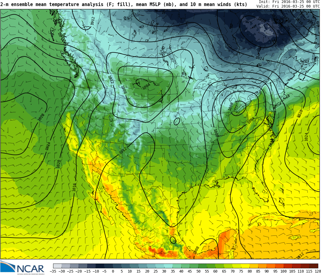
Found a new webpage that show NCAR ensembles, and these weather maps look really clean! These are useful for forecasting when you get up in the morning and want a nice review of the day ahead of you :)

The NCAR ensemble is a 10 member ensemble run at 3-km horizontal resolution initialized once a day at 0000 UTC and run for two days.

Here's the maps for the southwest 2-m mean temperatures, sea level pressure, and 10-m wind:  http://ensemble.ucar.edu/images.php?d=2016032500&f=t2_mean&r=SW&i=1
(note: you can toggle on/off the county lines by pressing [o])


Also interesting is seeing the data assimilation for the model. Here's a map showing the locations of the data used in the model.

The data assimilation is feed into another model to create a 15-km analysis of atmosphere every 6 hours which is used in the forecast model. You can look at analyses here: http://www.image.ucar.edu/wrfdart/rta/images.php?d=2016032500&f=t2_mean_f000_ANLYS&r=CONUS

Sunday, March 6, 2016

FROPA (That's short for Frontal Passage)

Watching another frontal passage this afternoon...


I'm expecting at least a 14 degree temperature drop at my house in Spanish Fork in the next 90 minutes.

Thursday, February 18, 2016

Cold Front

On days like today the atmospheric sciences department cancels classes and graduate students abandon work. Students lined up against the window of the 8th floor conference room in the William Browning Building today as a massive cold front, the strongest one in years, approached. The cold front hit the University of Utah at 11:35. Temperatures dropped 20 degrees in fifteen minutes.


Notice the crane turned to the north. This is before the frontal passage with winds still strong from the south.

The crane turned south after the frontal passage.


Strong Winds

Strong winds in northern Utah this morning preceding a winter storm. Shown below is wind speed and wind gusts in mph.

Looks like the cold front and precipitation is on it's way...

Right now the Cold Front is at Dugway. Look at the drastic temperature contrast! On the east side of the front temperatures are at 10 C, warm enough to get away with a jacket. On the west side of the front in the cold air, temperatures are at 2 C, near freezing!


From the HRRR, looks like the front is expected to reach the Salt Lake Valley between 12:00 and 1:00.