
Friday, October 2, 2015

Thunder and morning clouds
Last night was the first time in a long time when lightning woke me up in the middle of the night. Around 4:30 AM my dark bedroom flashed with light, followed by a loud crack from outside. I ran upstairs to watch the storm pass. It rained for about 30 minuets.
The storm has since moved north. My sister and mom shared this picture with me of the clouds in the morning looking west.

 |
| Radar image at 4:45 AM local time |
 |
| Rain accumulation at my station in Spanish Fork. Rain started around 4:40 and ended around 5:00 Am |
The storm has since moved north. My sister and mom shared this picture with me of the clouds in the morning looking west.

Tuesday, September 29, 2015
Great Salt Lake Time Lapse 1984-2012
This image from Google's Earth Engine shows the size of the Great Salt Lake between 1984 and 2012. I image in the strength of the lake breeze is affected by the size of the lake, especially in recent years when Farmington Bay is almost completely dry.
If you zoom into Utah Lake you'll see it hasn't changed much.
Try looking at other areas, like your neighborhood, and see how it's changed!
If you zoom into Utah Lake you'll see it hasn't changed much.
Try looking at other areas, like your neighborhood, and see how it's changed!
Monday, September 28, 2015
Lunar Eclipse
 |
| Supermoon lunar eclipse on September 27, 2015. Photo taken from the University of Utah. |

The moon has a reddish tint to it. This red color is caused by light scattered by earth's atmosphere, essentially the same phenomenon that causes red sunsets.
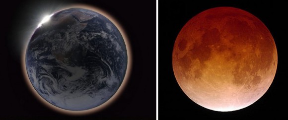 |
| Left image illustrates light being scattered and refracted by earth's atmosphere. Blue light is scattered most efficiently (that is why the sky is blue). With enough scattering (by a long path through the atmosphere) only red light makes reaches the moon shown on the right. |
Friday, September 25, 2015
Adventure on Fremont "Island"


We drove out to the island yesterday morning to set up the weather station. Yes, you read that right, we drove to the island. The cartoon map image above is a little deceiving. The Great Salt Lake Level is actually really low and there is now a land bridge that makes driving to the island possible. Note: The island is privately owned. We had permission from the owner to set up the weather station and he escorted us to the island. You can see from satellite images the land bridge that exists between the Antelope Island causeway and Fremont Island. When the lake level is high it is best to take a boat.


The image on the left shows when the lake is high. The right image was taken on 10 September 2015, just over a week prior to our excursion. The drive on the lake bed is really flat and sandy, as you can see below. That hill in the distance if Fremont Island.

Castle Rock is the highest point of the Island. We didn't hike there, but there is a famous cross carved in the rocks by Kit Carson who explored the west with John Fremont.

.jpg) |
| Kit Carson's cross (photo from the internet) |
The images above makes it look like the island is barren, but the island really has diverse a diverse blend of vegetation and geological formations. Our wet summer has kept the plants green. The sagebrush especially gives lots of color to the island.

The island owner pointed out some cool rocks. They are little cubes of iron. I'm no geologist, so I can't say anything more about them.

After some wild four-wheeling on the island, we reached Miller's Point or Miller's Hill which turned out to be a perfect place for a weather station.
 |
| Our escort had an ATV. |
 |
| Climbing Miller's Hill |
 |
| Millers Point Survey Marker |
 |
| Installing weather station on Miller's Hill. |


 |
| Had to get my "Station Selfie" before we left. No idea when or if I'll ever be back here. |

Weather data from this station (and thousands of other stations) can be accessed via MesoWest.
Here is the past 24 hour temperature:

Past 24 hour winds:

More information about the island at Deseret News and this blog.
Subscribe to:
Posts (Atom)