Sunday, June 29, 2014

Day Trips from Spanish Fork

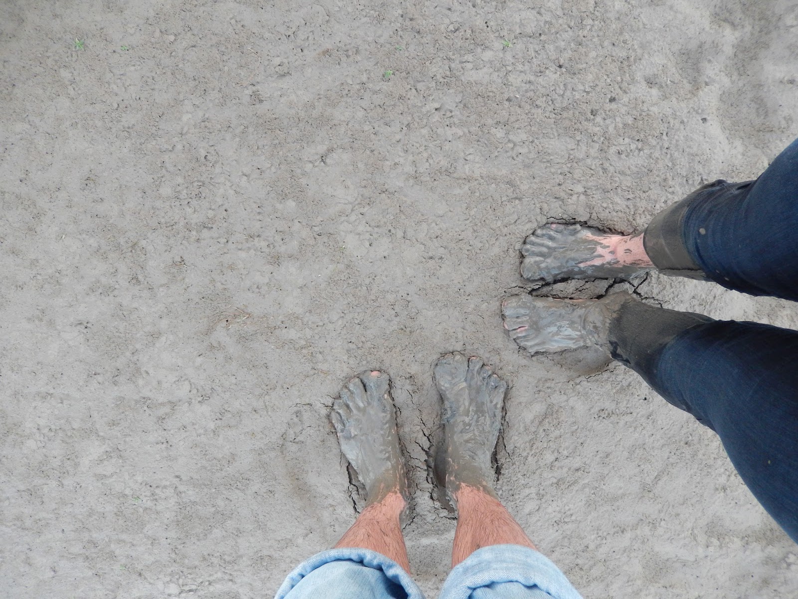
Summer is perhaps my favorite time of year (Christmas is my other favorite time of year). I love any time I spend with my family and enjoy outdoor activities. Just yesterday we hiked to a place called The Grotto a few miles up Payson Canyon and my sister and I played in the mud at Utah Lake. There is so much fun stuff to enjoy just a short drive from my home.

In 2011 I was a famous on-air TV personality for Spanish Fork City Network. I think five people saw me on TV. Anyways, I created this Sunday Night Special called "Day Trips from Spanish Fork." Enjoy!

Friday, June 27, 2014

Who has the best forecasts?

Lots of people tend to blame the weatherman. Here is a good read about weather forecast accuracy: 
http://www.businessinsider.com/the-most-accurate-weather-forecasts-2014-6. 
The author mentions a book called "The Signal and the Noise" by Nate Silver. I've read that book, and it is a very good read.

The below chart is in the article and book. A perfect forecast is along the black line. The NWS comes closest to the black line while the local TV meteorologist are less reliable. On-air meteorologists love to forecast rain more often than it actually occurs. The Weather Channel forecasts are pretty good, but they like to forecast rain when there is a small chance.


Summer: Different Air Quality Issues

In the winter months everyone is concerned about the inversion and PM 2.5 concentrations. Our valley inversions especially get a lot of attention because they obstruct visibility. Summer comes with its own pollution problems--ozone.

Below are the trend charts for ozone and PM 2.5 for Salt Lake City.

Yesterday's storms cleaned us out, but our ozone levels have been inching high the last few days. 

You may have heard of ozone being a good thing in the stratosphere--it protects us from dangerous UV radiation--but breathing ozone is not good for you. 

Where does ozone come from? It is a product of fossil fuel burning cooking in the sun.

The Uintah Basin is a "special case" for ozone pollution. We often observe extremely high concentrations in the winter months, but in the summer there is usually less than Salt Lake, as shown in the chart below.

(Oh, and the spikes in the PM 2.5 yesterday were likely caused by gusty winds associated with the storm front.)

Green Summer

Landsat is a program of polar orbiting satellites that started in 1972. While orbiting they scan the earth measuring different wavelengths of light, essentially taking a picture. Over the course of several days they have passed over most the earth. Currently, Landsat 7 and Landsat 8 are in operation. One primary purpose of the Landsat program is to keep a record of the changing land use in the world. 

On June 12, 2014 it passed over Utah and created this image. It's amazing how green this desert in the west can get. What a wonderful place to call home!
Source: Landsat
The large body of water is Utah Lake. Strawberry reservoir is to the east. Down the middle is the Wasatch Range and Uintah National Forest.

I wasn't in Utah at the time of this picture, but I'm in the one below! This is Charlottesville, Virginia on June 2, 2014.
Source: Landsat
It's hard to pick out landmarks (so many trees and I'm not too familiar with the area), but I-64 is the main road running west to east and US-29 is the road running north to south.

The newest satellite in the program, Landsat 8, measures 11 bands of radiation. Only three bands are needed to create a true color image (red, green, and blue visible light) and the other bands give us additional information. More information about what each band measures can be found here.

One cool thing we can do with the 11 bands is distinguish snow from clouds. The algorithm that processes the images gives snow a bluish tint. Shown below is an image of the Uintah Basin on January 12, 2014. The bluish tint is an indicator of snow.
Source: Landsat
These images are important for air quality research because we only see high levels of ozone pollution in the Uintah Basin when the ground is covered in snow.

To explore Landsat images, go to http://landsatlook.usgs.gov/.


MODIS is another instrument on a polar orbiting satellite. 
You can find MODIS images in near-real-time here
(Warning: This site will use all the RAM on your computer.)

A post about MODIS can be found here.

Thursday, June 26, 2014

Virga

Dark clouds are covering parts of Utah. I felt a few rain drops this morning when I was walking to work. It's trying to rain, but most of it is evaporating before it hits the ground. This kind of rain is called Virga.

We see in Utah County that the clouds are dark, but it doesn't look too wet. This is a view from American Fork looking west.

Another view this morning, from Salt Lake looking south...

The radar composite scan (the sum of all the radar scans at all elevations) shows a lot of rain drops... 
...but if we look at just the base scan (0.50 degree angle) we see much less reflectivity. This indicates that most of the rain from above is not reaching the ground. 

Around noon a cold front will pass through Utah. This will bring rain, cooler temperatures (80ish), darker clouds, and possibly some lightning.

For the weekend the upper level flow becomes zonal and we'll see sunny skies and temperatures in the mid 80s.

Wednesday, June 25, 2014

Uintah Basin Topography

The Uintah Basin often experiences days of unhealthy air quality. How is it that this rural basin gets more polluted than Salt Lake or Utah valley? One reason is because of the topography. The image below shows the topography of the state and a zoomed in section of the Uintah Basin. The Uintah Basin is surrounding by high mountain barriers on all its sides. The Salt Lake and Utah valleys, on the other hand, have lower elevations with adjacent valleys that pollution can mix into during inversions. Still, the winter inversions along the Wasatch Front are strong and the large population causes poor air quality.

Tuesday, June 24, 2014

Big Brush Creek Cave

Last weekend my brother and I went camping with some friends from church. We drove to the High Uintah’s north of Vernal Utah. I brought by weather radio to stay updated on any potential thunderstorms in the area. The forecast when I left showed a 20% chance of storms. The limiting factor for any storm development would be the dry air and the cooler air mass that had moved over the region. Still, the intense daytime heating could be enough to pop up a thunderstorm.

The Uintah Basin has been the focus of my research the last two years. The basin is heavily populated by oil and gas wells. These wells are the primary cause of high pollution periods during winter inversions, especially surface ozone. Lucky for us it is summer and we can see the mountains around us and enjoy the clean air.

A short wave trough dipping into Utah brought some cooler than normal temperatures for the weekend. This disturbance brought some moisture and clouds. With the daytime heating some cumulus clouds developed over the mountains. Some clouds grew dark, but I only felt two raindrops the entire weekend. The air was too dry to rain. Virga was often seen in the distance during the afternoons. Several individuals in the group worried we would get caught in a thunderstorm, but no one saw any lighting or ever hear lighting. The scariest sound we heard where the coyotes in howling all night.
 
Saturday we explored Big Brush Creek Cave. At the wide mouth of the cave is a giant ice column that slowly melts away all summer long. It was early enough in the year that is was still touching the roof of the cave.


Our group explored the smaller arm of the cave. On our hands and knees we crab-crawled through the entrance and down to 700 feet below the earth’s surface. Some parts of the cave opened wider and other areas were a tight squeeze. At one section, with a running start, we penguin slid on the ice through a narrow tunnel. There were more ice columns throughout the cave, but they were much smaller than the big one at the entrance. The deeper we wandered, the ice melted and we were walking through water puddles. I thought it was odd that we found water deeper in the cave, but it makes sense because the earth is an insulator and keeps the temperatures inside the cave around 50 degrees year round (temperature measured with a Kestrel). The ice near the front of the cave is there because it is exposed to the winter temperatures. The water freezes in winter and slowly melts through the summer.


On the way home I saw some of the most beautiful late-evening convective cumulus clouds hanging over the Uintah’s. We also enjoyed a beautiful sunset as we drove through Spanish Fork Canyon. 

Tuesday, June 17, 2014

Fresh Snow

June surprised Utah with some fresh snow at levels above 8,000 feet. I haven't seen the snow yet, but it has been windy all afternoon in Vernal, Utah. We must be experiencing some sort of downslope wind storm coming off the Uintah mountains from the system that moved through northern Utah.

At the Mountain Meteorology Lab you can see snow in the distant mountains. That white stuff wasn't there yesterday.

The most recent image from Alta Ski Resort shows it's pretty white up there. My professor said he put his skis away for the season. I wonder it he'll get them out for this unexpected summer snow storm.


The winter weather advisory is still in affect for the Wasatch and Uintah mountains this evening. Spanish Fork got 0.3 inches of rain out of this storm, much less than Salt Lake. The airport got over an inch of rain in the last 24 hours!

Saturday, June 14, 2014

Cool Down

Looks like some cool weather will greet me as I return home...

Update: Flying over Utah Lake we experienced some turbulence. It must have been the front edge of the upper cold front. The plane dropped suddenly and everyone gasped and grabbed their arm rests. After a brief silence while the plane stabilized, the cabin erupted in laughter :) 

I missed the perfect opportunity to get a picture of radiation fog in Charlottesville. I'm kind of disappointed in myself. I guess I was too memorized looking at the fog. So here are some other pictures:

Our tiny plane in Charlotte, North Carolina.

North Carolina, lots of trees!

Nice stratus deck below the Appalachian Mountains.

No clouds, no trees...somewhere in New Mexico.

Mountains of Arizona.

Utah County, my home. Nice cumulus clouds developing over the mountain peaks.

On the ground. It is good to be home.

Wednesday, June 11, 2014

Severe Storms!

I did it! I survived my first Tornado Watch!
Source: weather.gov
Source: Wunderground.com/radar
Red shaded area indicates Tornado Watch area.
Ok, the watch was technically south of Charlottesville and the warning expired before the storm reached me. Oh well. I've experienced worse storms than this one anyways. 

The individual cells approaching Charlottesville diverged as they approached the city. On my walk back from class I felt a few sprinkles, but hardly enough to get the ground wet.


While Charlottesville dodged the storm, storm spotters reported strong winds and quarter sized hail near Lynchburg and Beckley, WV.

Radar is one of the most handy tools for nowcasting the weather (nowcasting describes the current weather and makes an extremely short weather forecast). The reason is because satellites don't take pictures often enough, and weather station data found on sites like MesoWest are not always "live" because of poor latency. Latency is the time delay between when an observation is made and when that observation is available for use. My weather station, for instance, sends an observation to MesoWest every 15 minutes, but it takes between 10 and 20 minutes before that observation appears in MesoWest's database.

Me and the storm splitting around Charlottesville.

The evening brought stratiform rain showers. CHAV2, south of Charlottesville, report 0.90 inches between 3 and 9 PM, and it's still coming down!
Source: Wunderground.com/radar
Source: Mesowest.utah.edu

UPDATE: June 12, 2014
Walking to class the morning after the storm I saw some of the aftermath--a lot of broken limbs and leaves on the ground. I heard from a friend that north of the university some larger limbs and also a tree had fallen down.
Add caption

Charlottesville shared this picture on their Facebook page:
Source: Experience Charlottesville

Sunday, June 8, 2014

Lightning Forecast

These fire flies are everywhere at night!
With one more week in Virginia that means I've got one week to experience a good, juicy southern thunderstorm. I've enjoyed the lightning bugs (I usually call them fire flies), but those small bugs aren't nearly as loud or dangerous as lightning.

Ingredients for a juicy lightning storm: moisture and lift. This week's forecast shows an approaching upper-level trough which will draw moisture from the Gulf and transport that moisture into Virginia by mid-week. Rain throughout the week is likely, but the best chance for a good lightning storm will be Wednesday and Thursday afternoon.

Below shows the June 8th 18z NAM forecast valid for Thursday 00z (Wednesday night).
source: weather.utah.edu
The NWS is calling for a likely chance of lightning. The Storm Prediction Center three day outlook show the potential for widespread thunderstorms the next few days. Below is shown the forecast for Storms will be scattered and largely affected by small scale topographic features and radiational heating, so we'll have to wait and see if one of the larger storm will cross over Charlottesville.

Update: June 11, 6:00 PM
The severe storm forecast has intensified since the Sunday forecast. Still a chance for storms on Thursday, but chances decrease as we move towards the weekend.

A camera in New York recently captured a tree being struck by lighting. Enjoy it!


Update July 1, 2014: Another exciting lightning video